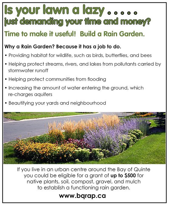
Build a rain garden this spring! Grants available for urban residents of
& Picton
Help protect water, lower impacts of flooding, support wildlife, & beautify your yard.
Build a rain garden this spring! Grants available for urban residents of
& Picton
Help protect water, lower impacts of flooding, support wildlife, & beautify your yard.

FOR IMMEDIATE RELEASE:
December 17, 2020
Due to changing weather conditions, ice is starting to form on lakes and rivers within the Watershed.
Quinte Conservation would like to remind residents that this early in the season, ice conditions can be very unpredictable, unsafe, and difficult to assess as above average flows in rivers and streams prevent the formation of stable ice surfaces.
Residents are advised to exercise extreme caution around all waterways as stream banks and fast moving water are both extremely dangerous. Adults are urged to keep children and pets away from all waterways, to stay off the ice, and avoid water control structures at all times. Hypothermia is a major concern for anyone who may fall into open water.
While Quinte Conservation does not measure ice thickness for recreational activities, the organization provides information on watershed safety conditions.
Quinte Conservation is issuing a Water Safety Statement regarding the changing ice conditions. A Water Safety Statement indicates that high flows, unsafe banks, melting ice or other factors could be dangerous for users such as anglers, boaters, swimmers, children or pets. Flooding is not expected.
This message will be in effect until (or updated before) January 15, 2021.
Quinte Conservation is a community-based environmental protection agency. It serves 18 municipalities in the watersheds of the Moira, Napanee and Salmon Rivers and Prince Edward County. It provides cost-effective environmental expertise and leadership. Quinte Conservation’s main goal is to create a sustainable ecosystem where people and nature live in harmony. More information about Quinte Conservation is available at www.quinteconservation.ca.
-30-
For more information contact:
Christine McClure
Water Resources Manager
cmcclure@quinteconservation.ca
(613) 968-3434 ext. 130 OR (613) 354-3312 ext. 130
or
Kirsten Geisler
Communications Specialist
kgeisler@quinteconservation.ca
(613) 968-3434 ext. 123 OR (613) 354-3312 ext. 123
Quinte Conservation | 613-968-3434 | 2061 Old Hwy 2, Belleville, ON | QuinteConservation.ca

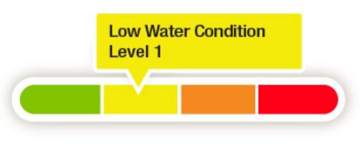
Media Release: 10 - 16 - 2020 Prince Edward County Watershed moves to Level 1 Low Water https://conta.cc/3dA135m
FOR IMMEDIATE RELEASE:
September 4, 2020
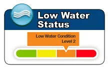
After a very dry June and July, the Quinte region experienced an increase in precipitation throughout the month of August. Groundwater and surface water conditions are still low for this time of year but are starting to improve. Quinte Conservation and this region’s Low Water Response Team have downgraded the Low Water Condition for the Moira and Napanee River Watersheds to a Level 1. Prince Edward County Watershed remains in Level 2.
Water supplies drawn from groundwater systems, and inland lakes and streams may still be sensitive and vulnerable. Residents who draw from these supplies may continue to experience issues with water availability and should take extra precaution with their non-essential use until groundwater levels have recharged.
Quinte Conservation would like to remind residents with vulnerable water supplies and those that take bulk water from these areas to voluntarily reduce non-essential water use by 10 per cent (Moira and Napanee Watersheds) and 20 per cent (Prince Edward County Watershed). Those in need of bulk potable water supply should check with their local municipality for availability and information on private water haulers.
Municipalities that source water from Lake Ontario or The Bay of Quinte have access to a more sustainable water supply. The delivery of water to residents on these systems is not impacted by current conditions. This conditions statement is not directed to residents accessing these municipal water supplies.
Quinte Conservation encourages residents experiencing low water to report their conditions using an online form. The form can be found at: https://arcg.is/1zX8b5 or on the main page of the Quinte Conservation website, along with tips for water conservation, at www.QuinteConservation.ca.
A Level 1 Low Water Condition means the potential for water supply problems has been identified. A Level 1 condition is managed through existing programs of the Conservation Authorities, municipalities and other key provincial agencies. Low water conditions are ranked as Level 1, 2 or 3 based on a prolonged period of low flows or precipitation. A Level 1 is the least severe and Level 3 is the most severe.
A Level 2 Low Water Condition indicates a potentially serious water supply problem. This level often means minor water supply issues are encountered and there is the potential for major supply problems. A Level 2 condition is managed through Conservation Authorities, municipalities and other key provincial agencies. This level indicates a potentially serious problem and conservation of water is extended to restrictions on non-essential uses and a 20% reduction in water consumption is requested. Low water conditions are ranked as Level 1, 2 or 3 based on a prolonged period of low flows or precipitation. A Level 1 is the least severe and Level 3 is the most severe.
This message will be in effect until (or updated before) October 8, 2020.
Quinte Conservation is a community-based environmental protection agency. It serves 18 municipalities in the watersheds of the Moira, Napanee and Salmon Rivers and Prince Edward County. It provides cost-effective environmental expertise and leadership. Quinte Conservation’s main goal is to create a sustainable ecosystem where people and nature live in harmony. More information about Quinte Conservation is available at www.quinteconservation.ca.
-30-
For more information contact:
Dave Eastcott
Water Resources Technician
deastcott@quinteconservation.ca
(613) 968-3434 ext. 126 OR (613) 354-3312 ext. 126
Quinte Conservation | 613-968-3434 | 2061 Old Hwy 2, Belleville, ON | QuinteConservation.ca

Issued:
August 28, 2020
Quinte Conservation owns just over 30,000 acres of land throughout the 6,000 km2 watershed. Some of those properties are conservation areas that are open for public use and collectively make up 75 km of nature trails. Over the last few months, these protected places have faced many challenges with non-permitted activities, overuse, and overall general disrespect of the integrity of the areas.
Visitors to conservation areas should be aware of non-permitted activities before entering and those include no camping and/or fires, no garbage dumping, no off-leash dogs, no alcohol or drug use, and no motorized vehicles on trails.
CAO Brad McNevin Says, "We receive reports every day about the mistreatment of these beautiful areas. We have four field staff to service our properties and if all they are doing is picking up garbage and decommissioning fire pits all day, then the projects they need to be doing can't be completed."
Quinte Conservation receives funding through a variety of avenues, however the largest amount comes from municipal funding and it is used for mandated programs like flood forecasting. The Authority relies heavily on donations, grants, and the paid parking program to support the conservation areas and does not have the resources to handle these challenges.
McNevin continues, "We are pleading with visitors to be respectful of these areas. We don't have the resources to keep up with this behaviour and if it continues, more of these places may face temporary closure."
Starting September 1st, paid parking will begin again at Quinte Conservation's areas.
McNevin adds, "We were happy to give visitors an opportunity to spend time in nature during this pandemic, but with everything that has been going on, the time has come to reinstate the parking fee."
At this time, Quinte Conservation staff would like to acknowledge all of the trail stewards, neighbours, and area users who have upheld the standards and taken it upon themselves to clean up after other visitors who have shown little appreciation for these outdoor spaces.
"We are so thankful to those that have taken time out of their day to keep us informed and those that have put their own safety at risk picking up a strangers trash during a world-wide pandemic so that the next visitor doesn't have to," says McNevin.
Conservation lands were established with the purpose of protecting the natural ecology and the overall health of our watersheds. Lands that had potential for recreational activities like hiking, birdwatching, and, picnicking are known as conservation areas. These lands are privately owned by conservation authorities throughout Ontario and activities, amenities, and use vary depending on the region.
Quinte Conservation's areas are open for public use every day (unless posted) from sunrise to sunset. These natural spaces are not parks and shouldn't be considered as such. Non-permitted activities can have a serious impact on plants and wildlife and can be detrimental to rare and endangered species. Visitors are asked to stay on marked trails and keep dogs leashed, take out garbage brought in, and follow leave no trace principles. These non-permitted activities are chargeable offences under Section 29 of the Conservation Authorities Act. Those in violation of the Act may be subject to a fine.
Quinte Conservation is a community-based environmental protection agency. It serves 18 municipalities in the watersheds of the Moira, Napanee and Salmon Rivers and Prince Edward County. It provides cost-effective environmental expertise and leadership. Quinte Conservation's main goal is to create a sustainable ecosystem where people and nature live in harmony. More information about Quinte Conservation is available at www.quinteconservation.ca.
-30-
For more information contact:
Kirsten Geisler, Communications Specialist
(613) 968-3434 ext. 123 OR (613) 354-3312 ext. 123

FOR IMMEDIATE RELEASE:
July 31, 2020
QUINTE CONSERVATION REMOVES SHORELINE CONDITIONS STATEMENT ISSUED FOR LAKE ONTARIO AND THE BAY OF QUINTE
Quinte Conservation has removed the shoreline conditions statement issued on June 26th for Lake Ontario and The Bay of Quinte.
Quinte Conservation uses lake elevation measurements of 75.3 m which corresponds to the level at which the lowest properties experience water over shoreline banks. The lake level is now below this elevation and is not expected to rise above it this year.
Lake Ontario’s water level continues to decline and was recorded at 75.1 m yesterday. This level is 17 cm above average and 56 cm below the recorded average set this time in 2019. Water Levels are expected to continue to slowly decline over the coming weeks and months.
Residents are reminded to take precautions along shorelines as unstable/unsafe banks may exist due to recent erosion and wave action. Those with properties in low-lying or flood prone areas should continue to monitor forecasts for storms and high winds which could lead to erosion from wave uprush. For information on flooding or for resources on Lake Ontario water levels, visit QuinteConservation.ca
FOR IMMEDIATE RELEASE:
July 30, 2020
QUINTE CONSERVATION ISSUES A LEVEL 2 LOW WATER CONDITIONS STATEMENT FOR THE QUINTE WATERSHED
Quinte Conservation and this region’s Low Water Response Team (LWRT) have declared a Level 2 Low Water Condition for the Quinte Watershed.
There has been a significant shift in precipitation patterns over the last three months. Since early May, below normal precipitation has persisted which has resulted in dry conditions with a noticeable decline in stream flows.
Water supplies drawn from groundwater systems, and inland lakes and streams should be considered sensitive and vulnerable. Residents who draw from these supplies may experience current and future issues with water availability and should take extra precaution with their non-essential use. Residents with vulnerable water supplies and those that take bulk water from these areas are asked to voluntarily reduce non-essential water use by 20%.

FOR IMMEDIATE RELEASE:
June 26, 2020
SHORELINE CONDITIONS STATEMENT ISSUED FOR THE BAY OF QUINTE AND LAKE ONTARIO
Quinte Conservation has downgraded the Flood Watch issued on May 15th for Lake Ontario and The Bay of Quinte to a Shoreline Conditions Statement.
Quinte Conservation uses lake elevation measurements of 75.3 m to determine a general flood line above which some properties will begin to be affected by water over the bank of the shoreline. As the lake level is now below this elevation and is not expected to rise above it this year, a Shoreline Conditions Statement has been issued.
Lake Ontario’s water level continues to decline and was recorded at 75.25 m yesterday. This level is 19 cm above average and 65 cm below the recorded average set this time in 2019. Water Levels are expected to continue to slowly decline over the coming weeks and months.
Residents are reminded to take precautions along shorelines as unstable/unsafe banks may exist due to recent erosion and wave action. Flood induced floating debris may cause issues for boaters. Those with properties in low-lying or flood prone areas should continue to monitor forecasts for storms and high winds. For information on flooding or for resources on Lake Ontario water levels, visit QuinteConservation.ca.
Staff will continue to monitor conditions and will provide an update if forecasts and conditions change.
A SHORELINE CONDITIONS STATEMENT: a FLOOD OUTLOOK STATEMENT gives early notice of the potential for flooding on the Great Lakes based on weather and lake conditions and water safety information.
This message will be in effect until (or updated before) August 28, 2020
Quinte Conservation is a community-based environmental protection agency. It serves 18 municipalities in the watersheds of the Moira, Napanee and Salmon Rivers and Prince Edward County. It provides cost-effective environmental expertise and leadership. Quinte Conservation’s main goal is to create a sustainable ecosystem where people and nature live in harmony. More information about Quinte Conservation is available at www.quinteconservation.ca.
-30-
For more information contact:
Christine McClure, Water Resources Manager
(613) 968-3434 ext. 130 OR (613) 354-3312 ext. 130

Discover GET OUT! Kids' CLUB for great nature-based educational activities and ideas that will keep your family engaged and entertained!
This new and exciting online club is a project of the Prince Edward Point Bird Observatory with funding from Nature Canada's NatureHood program.
Nature provides an endless source of things to explore, discover, think about, and discuss. Take some time to go slow, be curious, apply all your senses, be kind, and have fun!
For all sorts of fun stay at home activities be sure to check the On-Line Deseronto Public Library Programs.